
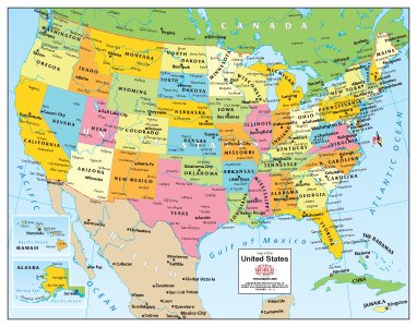
This political US desk map has a distinctive and modern look. Each beautiful map features richly colored states of the United States, neighboring nations, and the major river systems on both set against pastel blue oceans. This map comes complete with insets of Alaska and central Hawai’i. Borders are shown for the visible portions of Canadian provinces, as well as provincial, state, and national capitals for Canada, Mexico, The Bahamas, Cuba, Jamaica, and the USA. A great reference for office or classroom. Paper, one-sided desk map. Size: 14″x11″
Features
- richly colored states
- richly colored neighboring nations
- major river systems


Reviews
There are no reviews yet.